
Guest Walk #1 - South Wales Heritage Coast

Hi! I'm Mair. I've been asked by my niece Helen to contribute a Guest Walk on her “Isle Walk Purbeck” Website. I live in the seaside village of Ogmore-by-Sea on the western end of the Glamorgan Heritage Coast, in South Wales. The walk I've chosen is a circular walk of about 6 miles starting and ending in Ogmore-by-Sea. Brody, a beautiful King Charles Cavalier, has walked these paths with the family many times.
This is a lovely corner of Wales! Within a few miles there is a huge variety of land and seascape, ranging from a beautiful valley where the River Ogmore flows out to the Bristol Channel, glorious sandy beaches, to towering cliffs with spectacular views across to Exmoor as well as much fascinating history.
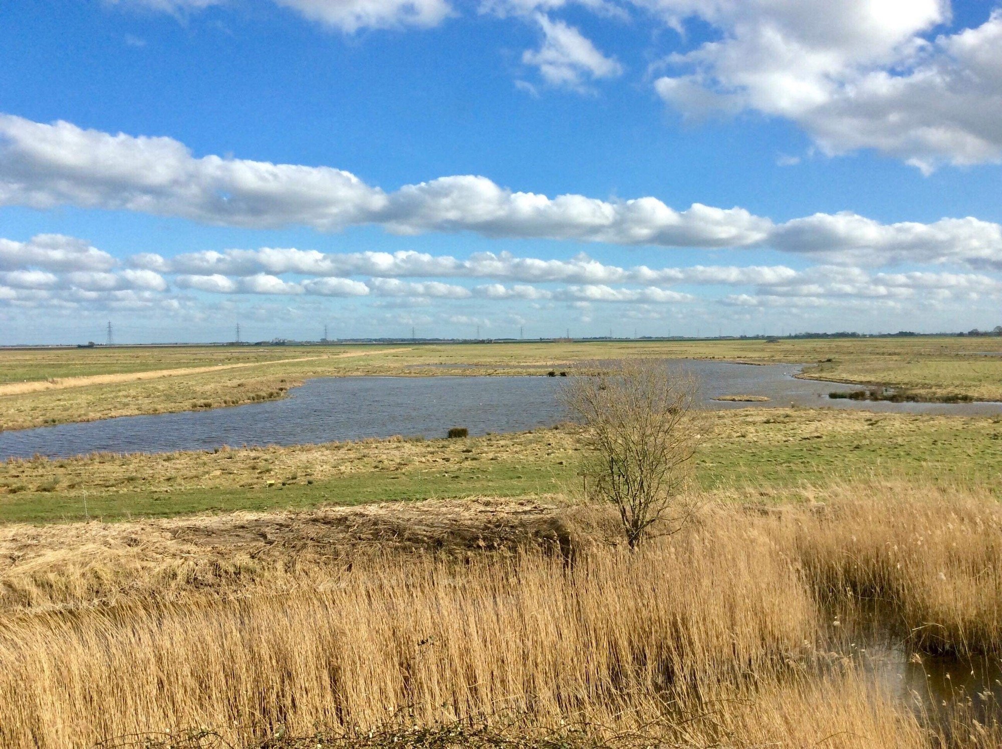
For those who've never visited this part of Wales before, I know you will have a wonderful walk. All of the photos are taken by Gemma Harker, except the one of the Ogmore Estuary. (Please note all distances and heights are approximate!)
Get your boots on!


To arrive in Ogmore-by-sea by car, take the B4524, from Ewenny just south of Bridgend. En route you will follow the valley of the River Ogmore and its tributary the River Ewenny. Passing through Old Ogmore village there is a ruined Norman castle. This is a great place to pause at, and children will love exploring the ruins, playing on the stepping stones that cross the Ewenny river and feeding the swans. There is also an excellent pub, the Pelican in her Piety.
Arriving in Ogmore-by-Sea, take the road to the Beach where there is a {pay} car park where your walk begins. There are the most amazing sea and country views! Upstream is the castle just described, with the backdrop of the hills along the mining valleys. And to the west across the estuary are the Merthyr Mawr sand dunes, amongst the highest in Wales and a haven for wildlife, and on a clear day, the Gower, and Worms Head are visible. Across the channel lies the coast of Devon and the hills of Exmoor.
At low tide the Tusker Rock guards the dangerous waters of the estuary. Without the presence of this rock (approx. 100 yards wide) the beauty of the Ogmore Estuary would have been lost, as it might have become at the end of the nineteenth century, a busy port, exporting coal from the South Wales mining valleys. It has been the graveyard of many merchant ships over the centuries. There today, rest the remains of the most recent wreck the “Steep Holme”, its rusted boiler and steel ribs still visible. One of the saddest wrecks was that of the “Malleny” in 1880 which went down with all hands. The grave of ten Goanese sailors that were recovered, is in the nearby churchyard of St. Bridget’s, in St. Brides Major. There are many wonderful fossils to be explored along the shores of the Heritage Coast together with many complex rock formations such as wave cut platforms. Dinosaur prints have been discovered this year further along coast. It is the Jurassic Coast of Wales!
With Ogmore -by-Sea on your left take the Welsh coastal path eastwards past small rocky pebbled bays, all having sweeping golden sands at low tide.

After about a mile and a half you arrive at a very steep sided grass ravine where the coast path climbs to the public highway. There is an alternative route however straight up the high green sides of the gully using steps cut into the bank by quarrymen long ago ascending from small coastal quarries, known locally as Jacob's ladder. These steps are not for the faint hearted! Originally Ogmore-by-Sea was known as Sutton and it is here that Sutton stone or Soapstone was quarried. It is soft and easy to carve but quickly hardens. It has even been used in the architecture of the Houses of Parliament.

Continuing along the Coastal path across high limestone cliffs with wonderful views are the headland of Dunraven Bay and of Witch’s Point. These are dangerous cliffs {approximately 150 feet high}and are unfenced. Take great care of any accompanying children and dogs! After about a mile from the ravine described above, the foot path leads you down a steep hill to the beach of Dunraven Bay with opposite a headland of carboniferous limestone striated with dramatic synclines and anticlines. As the headland descends to the water there is a reef known as Witch’s Point, or Witch’s Nose, (Trwyn y Witch in Welsh) which is a perfect description. As on Tusker Rock, this rocky headland and reef has seen many ships wrecked there over the years. In bygone years it was said to be a haven for wreckers such as Matt of the Iron hand!

Continuing through a gate opposite, the path leads you through Dunraven Park with its beautiful walled gardens which are part of the grounds of the former Dunraven Castle now demolished. The mansion of Gothic design with twin castellated wings facing seaward was in its heyday the Downton Abbey of Wales and even had Royalty coming to stay! Walking through the gardens, with the ice house in one corner you emerge through woods at a cliff top overlooking Temple Bay with its wave cut platforms, where there is a sudden two-hundred-foot drop, fortunately fenced. There are also the remains of an iron age fort on the headland. Before leaving the headland look out for clumps of rabbit fur, it is said that rabbits are reputed to have drunken fights there after eating hellebore which is toxic and inebriating to rabbits! This is the furthest outward leg of your walk.

Leaving Dunraven Park, turn immediately right, up a small valley, with the Heritage Centre on your right (ideal for excellent information and orientation about the Heritage Coast). This building was previously Dunraven Castle laundry in bygone days. Leading up through the little valley there are woods where there is a footpath on your left crossing farmland and over a stile to the Main Road and the Three Cups pub in Southerndown village, where there is an opportunity for some well-earned refreshment. There is a bus stop opposite with hourly buses to Ogmore -by-Sea.
Those who wish to continue on foot can leave the public highway at the western end of the village and with a gentle uphill stroll reach Groes Farm. Turning right at the farm you come to the hamlet of Heol y Mynedd at about 300 feet, with good views across the downs. Taking a footpath straight ahead you turn left into a secluded valley known as Pant Marie Flanders. Brody enjoyed his walks down the Pant (A hollow in Welsh). The path descends gradually down through the valley, to join the B4524 to Ogmore-by-Sea at Portobello. There is an ancient stone well with clear drinking water at the end of the valley walk.
And so, returning along sandy paths by the river Ogmore to the car park your walk is complete.
Hopefully there will be a spectacular Ogmore sunset gleaming across the water to greet you at Journey’s end.

More Ramblings


Meet Cat, she’s walking home, a very very long way! 630 miles to be exact, along the South West Coast Path from Minehead to The Isle of Purbeck, Dorset. Join Cat on her journey as she shares the ups and downs of her adventurous walk home.